Concept Design for the World's Dumbest Reservoir
Failing to solve California's looming water crisis
The funny thing about global warming is that it’s going to increase the net rainfall in the world, not decrease it, but depending on the region of the world you’re in, it’s going to screw you in different ways. A lot of folks don’t understand that, and some of my friends were asking me today how that could be, and the resultant conversational rabbit hole was so interesting I figured I’d write it all down. If abstract environmental prognostication is your thing, read on. We’re going to cover the science of rainfall, the impacts of global warming on US regions, and solutions for California’s looming water crisis, leading us to game plan one solution that very much sucks ass. Let’s begin.
Physical Meteorology in Three Minutes
Water vapor exists in the atmosphere. The warmer the air is, the more water vapor can fit in an idealized ‘box’ of air, because of how vapor pressures work. Dalton’s Law says that the partial pressures of all the different gasses in a box of air add up to the total air pressure of the box, so you can squeeze more water in a higher pressure box than a lower pressure box. The ratio of the partial pressure due to water vapor to total idealized amount of water you could squeeze into the box before some of it starts to precipitate out as liquid water is the relative humidity of the box.
Cloud formation comes from pseudoadiabatic lifting of moist air parcels, which basically means that the box of air with the water vapor in it gets lifted up in the air but mostly retains its prior heat energy, due to water having a high specific heat. When it goes up in the air, the total pressure of the box goes down because air pressure goes down with elevation, but the partial pressure due to water vapor in the box stays the same because the water hasn’t gone anywhere, and when that box of air reaches a spot in the sky where it hits 100% humidity, water droplets start to precipitate out and form clouds. Pilots call this elevation “the ceiling,” but meteorologists call it the “lifting condensation limit.” And given a known ground level humidity and temperature, and a known distance of [into-the-air-box-raising], you can calculate how much water precipitates out to form clouds, and potentially rain. You use computers for this, but when you’re taking your final exam in Graduate Physical Meteorology class, you use a chart that looks something like this:
Boxes of air rise for three reasons:
1.
A frontal boundary comes in and a wedge of cold air forces warm air upper into the atmosphere. Cold fronts have steep edges which push the air up quickly, causing violent thunderstorms.
Warm fronts have flatter slopes which cause several days of drizzle.
2.
Hotspots on the ground or differential temperatures along coastlines cause puffy afternoon clouds to create scattered thunderstorms as we see in the south or the tropics.
3.
Or, sometimes there’s a big ass mountain in the way.
This third means of cloud formation is called a “rain shadow,” and it’s the most important when we discuss how global warming can make some places have less rain, or more rain that’s less usable. Because the rain falls on the upwind side of the mountain, the air that makes it over the mountain is dry.
Global Warming Stuff
On net, more heat means more evaporation and also more convection. More convection means more of the water vapor made by the more heat will go up, and more rain will fall down. The net amount of rainfall in the “warmer earth” case will noticeably increase, but it won’t necessarily be a good thing for people who are already in desert climates due to other factors. Because of Coriolis forces, air generally travels in a northeasterly direction in the USA. Areas east of the Mississippi get most of their moisture from the Gulf of Mexico, and west of it get it from the Pacific. But because there are numerous big ass mountains in the way, the increased rainfall is going to be most noticeable on the West Coast and east of the Mississippi, and the Midwest is stuck in that rain shadow. You can see how this works in isohyetal maps.
And here’s a topographic map specially annotated by HWFO:
Basically the green areas on the isohyetal map are going to get greener, and the orange areas are going to stay roughly the same, because of the rain shadow. But they’ll be basically the same while warmer, which means increased irrigation demand on crops in places like Nebraska.
The former dustbowl states have maintained robust agriculture over the past century by better soil conservation practices and by irrigation from deep wells tied into their aquifers, but their aquifers have been strained since the 2012 drought and management of them is going to be important if they want to continue growing all that corn for ethanol production and pig feed, but that’s not what this article is about. What’s truly interesting is that some places may be screwed even though they get more rain. Places like California.
In the water resources field, we balance elements of the hydrologic cycle to try and make sure people have water for what they need, and we do this by storing it. The groundwater table is a storage reservoir. Manmade lakes are storage reservoirs. And glacial ice is a storage reservoir. In the southeast where I live, I expect the “more rain” to reduce many of our water resources stressors as we slowly turn more tropical, but California has a reservoir problem.
California has almost 1,500 reservoirs, which supply 15% of their electricity and 60% of the water used by cities and agriculture. But they deeply rely on the mountains themselves to store the water they need, and in a warming world not all melt from snowpack makes it downstream as anticipated. In 2021, California’s melt estimates were off by 68%.
Presuming the droughts become more infrequent on net in California with the rise of evaporation and convection, but presuming this warming eliminates the snowpack they’re using as a reservoir, what should California do?
The Very Dumb Reservoir
Reservoirs are one of the coolest and most important elements of first world living that exist, but you need the geography to play along with you. You want to build a reasonably sized dam, but you want your reservoir to be deep, and not flood out a lot of people in the process. A fifty foot deep reservoir holds five times as much water as a ten foot deep reservoir does. Stated another way, a ten foot deep reservoir has to cover five times as much area to hold as much water as a fifty foot deep one.
If you really wanted to, you could dam up the spot where the Sacramento and San Juaquin Rivers come together in Antioch California, just downstream of Sherman Island County Park. It’d be very easy. Do it right here:
It wouldn’t have to be tall either. About a four mile long pile of dirt twenty five feet high with some sort of relatively simple outlet works that included a spillway. A tremendously simple dam. Just pond the water up twenty feet above sea level and hold it back for all of California to suck off of during drought conditions. An idea so simple it’s amazing nobody’s every done it.
Nobody’s done it because it sucks.
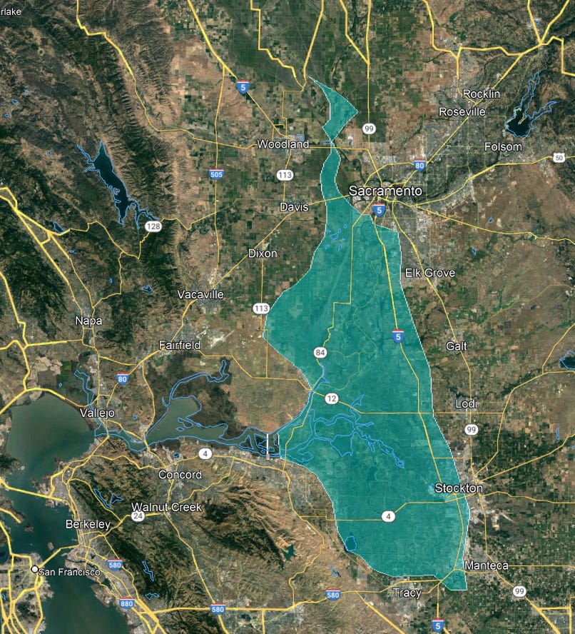
The Central Valley of California is flatter than much of Florida. Our idealized dam concept, holding back water only to around twenty feet mean sea level, would flood an area all the way back to Sacramento and past “The 5.” Something like this:

It would turn Elk Grove, Galt, and Lodi into lakefront cities, would flood portions of Stockton thirty miles away, and would flood some of south Sacramento. They’d have to relocate Interstate 5, and the citizens of a dozen towns in the area. The resultant reservoir would be 1000 square miles, larger than San Francisco Bay itself, but only an average of about ten feet deep. And because it’s so shallow, it would only hold around 6.4 million acre feet, or one nineteenth of the water in Lake Tahoe despite being over five times bigger. A few foot change in elevation of this lake, owing to necessary seasonal variations in lake management, would create miles of dried out mud flat.
50% of the entire watershed of California flows through that dam location, at a clip of around 25 million acre feet per year. California’s current water use state wide is around 87 million acre feet per year, which is quite a lot more, but comes from a variety of existing sources. There’s an argument to be made that this sort of reservoir could be properly managed to stay hydrated, and could supply a large amount of fresh water to both the valley and to the Bay Area, but that argument only really holds if the flows into it are regular and generally match demand.
But if the snowpack melts, they won’t be. Which defeats our conceptual purpose of the lake. This lake would be mostly dry in the summer, and get drained down to almost nothing to not only provide water, but also to provide storage for stormwater during the rainy season to compensate for the lack of glacial storage.
It would be the ugliest reservoir ever. Maybe they could cover it with windmills or something. And the only remaining logical solution to the looming water crisis in California seems to be to build a half dozen nuclear power plants and run desalination facilities with them.


The Delta is a political swamp (pun intended) due to long-standing environmental issues, such as "rare and endangered" fish, "salt water intrusion" and sensitive habitats at the edge of the historical marsh (Jepson Prairie).
https://en.wikipedia.org/wiki/Jepson_Prairie
Expecting the bizarro political forces in California to be able to do the right thing to conserve fresh water is almost beyond comprehension.
I used to read this blog a lot, but farcebork stopped sending me notifications for unknown reasons.
https://mavensnotebook.com/2022/06/23/delta-independent-science-board-delta-conveyance-project-update-on-environmental-documents/
I was in the Rio Vista area about a week ago, and ran across an employee at the Ryde Hotel who said he heard from old timers that the Delta region has been mostly undeveloped since Prohibition because some super rich old money family (Comstock silver, 1800s) had purchased a large oil/gas field there, that has mostly gone unexploited.
fwiw, the bakery in downtown Rio Vista has excellent Cambodian soup (similar to Vietnamese Pho).
The old China "town" area in Locke, just upstream from Walnut Grove, is rumored to be up for world heritage site designation soon.
There are two famous river crossing ferries still operating (by the State of California Transportation Dept.) upstream from Rio Vista that I keep trying to take, but they are intermittent and when I've gone lately, they had just closed for the day.
https://dot.ca.gov/caltrans-near-me/district-4/d4-projects/d4-solano-delta-ferry
Many areas of the delta are surprising (very lush compared to most of California) and driving/cycling/boating in that area is like time travel due to the lack of modern development.
This is an excellent story about a small landowner and recreational business dude in the Delta beating the vast legal death machine of the State of California:
https://twitter.com/bucklerisland